


"This new approach to project planning and development expands the department's requirements for engaging local and planning partners by requiring collaboration with stakeholders before project scopes are developed. PennDOT Connects aims to transform capital and maintenance project development by ensuring that community collaboration happens early, and that each project is considered in a holistic way for opportunities to improve safety, mobility, access, and environmental outcomes for all modes and local contexts." PennDOT Connects Policy Statement
Bicycle and pedestrian connections under and around I-95 are an important part of the reconstruction of I-95 at the Bridge Street Ramps/Betsy Ross Bridge Interchange (BSR/BRI). These connections are intended not only to enhance safety and accessibility for non-motorized users but also to provide stronger links between neighborhoods on either side of the highway. By incorporating dedicated facilities for walking and biking, the project seeks to improve connectivity to nearby transit services, schools, commercial corridors, and waterfront amenities, while supporting broader regional goals for multimodal transportation.
The full list of planned and completed neighborhood improvements appears below. Click a tab to read more about the improvement.

Rendering Showing the New Bridge That Will Carry the Delaware Avenue Extension and Shared-Use Path Across Old Frankford Creek
The Adams Avenue Connector was completed in late 2020, as part of Section BS4. The work included the reconstruction of Aramingo Avenue from Wheatsheaf Lane to Church Street, the replacement of the Aramingo Avenue bridge over Frankford Creek, and the construction of several new ramps. The project also built the Adams Avenue Connector between Torresdale Avenue and Aramingo Avenue, which incorporated a section of the Frankford Greenway. Improvements included a trail gateway at the intersection of Adams and Aramingo Avenues.

Aerial Photo at the Frankford Creek Greenway Along the Connector, Looking South
The removal of the I-95 northbound on-ramp will bring opportunities to create safer and more efficient connections to the waterfront from Bridge Street. Under Section BS2, which is currently under construction, the intersection of Bridge and Tacony streets is being improved to include new sidewalks and street lighting, and a new shared-use path on Tacony Street.
Under BS5, Bridge Street is slated for new bicycle infrastructure from James Street to the Richmond Street Extension, which will eventually connect to the Delaware Avenue Extension. Between James Street and Tacony Street, Bridge Street will have a shared-use path, allowing cyclists to safely use the crosswalk at Bridge and Tacony Streets.
Between Tacony Street and Ramsay Road, the design includes protected, conventional bike lanes on each side of the street. Between Ramsay and East Thompson Street, it transitions into a bi-directional protected bike lane on the north side of Bridge Street. From East Thompson Street to Richmond Street, the facility transitions into a shared-use path to accommodate vehicles, bicycles, and pedestrian traffic. The shared use path continues onto Richmond Street Extension.
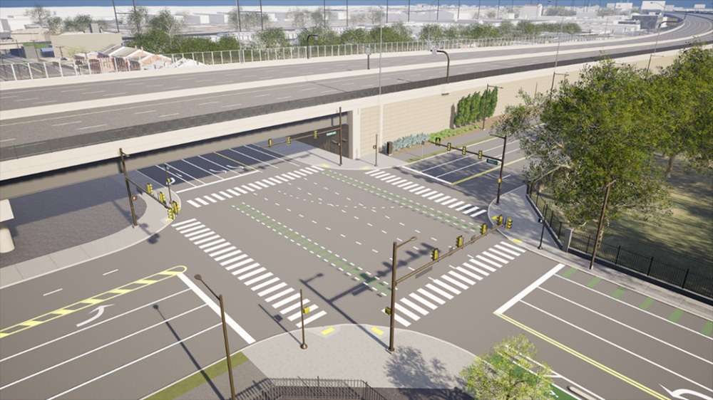
A Rendering of the Intersection of Bridge and Tacony Streets
Typical Completed Roadway Section
Recognizing the importance of providing safe and accessible bicycle and pedestrian infrastructure to the Bridesburg community, BS5 will construct a shared-use path along the proposed Delaware Avenue Extension. The design will enhance access to the Delaware River waterfront and regional trails, such as the Delaware River Trail and the Kensington and Tacony (K&T) Trail.
The shared-use path will be bi-directional and accommodate both cyclists and pedestrians. It will be separated from travel lanes by a buffer for added protection and will be raised above the roadway to further separate it from vehicular traffic. The shared use path will connect to the newly opened Robert A. Borski Park, Frankford Boat Launch, and other bicycle and pedestrian infrastructure on the Richmond Street Extension and Buckius Street Extension. It will fill a key gap in major national and regional trail networks, including the East Coast Greenway and the Circuit Trails, the Greater Philadelphia multi–use trail network.

Map of Delaware Avenue Extension and Trail Connections (Section BS5)

Typical Completed Roadway Section (Section BS5)
Bicycle and pedestrian improvements have created opportunities for Bridesburg residents to connect to recreational and other community facilities and the Delaware River Waterfront. The shared-use paths on the Delaware Avenue Extension, Buckius Street Extension, and Richmond Street Extension all connect to key recreational amenities in the neighborhood, including Robert A. Borski Park, Frankford Boat Launch, and the Bridesburg Recreation Center.
Borski Park, which opened in July 2025 as the newest addition to the parks in Bridesburg, was developed by Riverfront North Partnership with Philadelphia Parks & Recreation. It is owned by the City of Philadelphia and managed by Riverfront North Partnership and Philadelphia Parks and Recreation. The park secured funding from several sources, including PennDOT.

 Robert A. Borski Park
As part of BS2, a shared-use path along Tacony Street is being constructed and will consist of a separated, paved path for bicycles and pedestrians from Aramingo Avenue to Van Kirk Street. This path will expand the local bicycle and pedestrian network, connecting existing and potential facilities along Aramingo Avenue with Bridge Street, the K&T Trail, and the Bridesburg and Wissinoming neighborhoods.
 Tacony Street Shared-Use Path
Retaining walls along Aramingo Avenue will be designed during BR3 and BR4 to be more aesthetically pleasing. They may include simple decorative textures to soften the visual impact or landscaping of embankments. Unobtrusive fencing may be added for safety. Coordination with the community will take place in the design of the walls.
Removal of Ramp K during BR4 will result in the creation of open space on the berm beside Aramingo Avenue between Bermuda Street and Buckius Street. The new public space will be designed in coordination with the community to minimize the visual impact of the highway and serve community needs.
A PennDOT-owned triangle of land located at the corner of Thompson and Juniata streets provides an opportunity to provide additional landscaping and screening to a vacant lot abutting highway right-of-way. The lot will be used as a construction staging area during BR3, after which time a permanent landscaping and screening plan will be implemented with neighborhood input. Additional neighborhood parking may also be considered.

Demolition of Ramp K during BR4 will require temporary removal of the American Legion Memorial Site and monument currently located below the structure at Milnor Street and Aramingo Avenue. Coordination will occur with the American Legion to discuss monument removal, storage, and potential relocation.
There is an opportunity to explore new sidewalks, lighting, and aesthetic wall treatments to improve the pedestrian conditions under the highway at the Orthodox Street underpass and create a gateway into the Bridesburg neighborhood. Coordination will occur with SEPTA to discuss potential improvements to or relocation of the Routes 25 and J bus stop currently located at the underpass.
 Current Conditions:
There is an opportunity to explore new sidewalks, lighting, and aesthetic wall treatments to improve the pedestrian conditions under the highway at the Richmond Street Bridge underpass. This will also provide an opportunity to create an inviting gateway into the Bridesburg neighborhood.


